NSW is copping rain and flooding while parts of Australia are in drought. What’s going on?
In some areas of NSW, more than 200 mm of rain has fallen in 24 hours. At the same time, dry conditions have gripped much of the continent.
Andrew King, Associate Professor in Climate Science, ARC Centre of Excellence for 21st Century Weather, The University of Melbourne, Andrew Dowdy, Principal Research Scientist in Extreme Weather, The University of Melbourne
22 May 2025
Emergency crews were scrambling to rescue residents trapped by floodwaters on Wednesday as heavy rain pummelled the Mid North Coast of New South Wales.
In some areas, more than 200 mm of rain has fallen in 24 hours. At the town of Taree, low-lying areas are flooded as the Manning River reached record levels, passing the 1929 record of six metres.
At the same time, South Australia, Victoria, Tasmania and Western Australia are in drought amid some of the lowest rainfall on record.
So what is going on, and when will the wet weather end?
Why is NSW so wet?
The wet weather in NSW is due to a combination of factors.
A trough is sitting over the Mid North Coast and stretching offshore. Troughs are areas of low pressure and can bring rain and unstable conditions. This trough is bringing extensive cloud and rain to the affected region.
In addition, winds from the east are also bringing moisture to the coast.
Since Sunday, all this has been compounded by a “cut-off low” in the upper atmosphere. These low-pressure systems are separated from the main westerly flow of winds, and often move slowly.
The combination of the trough near the ground, and low pressure at higher levels in the atmosphere, can cause air to converge and rise. As air rises it cools, moisture condenses and rain occurs.
In the next few days, the cut-off low will move away but is likely to be replaced in the same region by another upper-level low-pressure system moving in from the southwest. This will likely mean heavy rain over the east coast region in the coming days and into Friday.
On top of all this, a persistent high pressure system in the Tasman Sea is also pushing cloud onto the NSW coastline.
An upper-level low with a high in the Tasman is a typical set of conditions for flooding on the NSW Mid North Coast. Those conditions are also forecast to persist for the coming days.
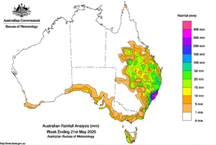
One-week rain totals over Australia ending May 21. Green represents heaviest rainfall.Bureau of Meteorology
So why are parts of Australia in drought?
The NSW north coast was quite wet in March and April – partly due to a hangover from Tropical Cyclone Alfred.
That meant the ground was already wet and full when rain began falling this week. So instead of soaking in, the water more easily turned to runoff and became floodwater.
But the differences are not unusual. Australia is a big place, and rainfall dynamics are quite localised. It’s fairly common to see very wet conditions in one area and very dry conditions in another.
Unfortunately the current heavy rain in NSW probably won’t make a huge difference to drought-stricken areas. The moist air flows are likely to dry out as they cross the Great Dividing Range. But a change in weather patterns means from Sunday, rain may fall in some areas of Victoria and South Australia suffering from drought.
A weather update on May 21 from the Bureau of Meteorology.
Is climate change causing this?
As the planet warms, scientists are very confident that Earth’s average surface temperature will warm, and heatwaves will get worse. However, rainfall projections are much less certain.
Projecting all types of precipitation is difficult. The water cycle is complex. Climate models – while powerful – can struggle to accurately simulate local rainfall patterns. And these patterns vary considerably over time – a natural phenomena that can make the climate trend hard to identify.
So what does this mean for autumn rainfall projections for Australia in future? None of the rainfall projections show a strong signal, and so scientists do not have high confidence in the results.
Having said this, there’s a hint of a drying trend across southwest Western Australia and parts of western Victoria and southeast South Australia, where conditions are dry now.
And for the Mid North Coast of NSW, currently experiencing heavy rain and flooding, autumn rainfall projections hint at slightly at heavier extreme rainfall.
Andrew King receives funding from the ARC Centre of Excellence for 21st Century Weather and the National Environmental Science Program.
Andrew Dowdy receives funding from University of Melbourne and is supported by the Australian Research Council.
This article is republished from The Conversation under a Creative Commons license.
RUGBY The Black Ferns are finding a balance between World Cup prep and putting out a winning side for Saturday's Pacific Four game against the United States More...
BUSINESS NZ Budget 2025: tax cuts and reduced revenues mean the government is banking on business growth More...